
Here you’ll find answers to some of the most frequently asked questions about Sea Link.
We hope they answer your questions and we will continue to update them as our work progresses. If your question is not listed below, get in touch with the team using the details provided on the Contact us page.
About Sea Link
Sea Link is a proposed electricity transmission network reinforcement between Suffolk and Kent, via a new, primarily offshore 2 gigawatt (GW) high voltage direct current (HVDC) link.
To bring the power from the subsea cables into and out of the electricity network in both Suffolk and Kent, we would need to build new onshore infrastructure including converter stations, substations and new underground and overhead electricity lines, as well as upgrading existing overhead electricity lines.
Power will be able to flow along the Sea Link cables in either direction, depending on where renewable energy is being generated at that time and where in the country power is needed.
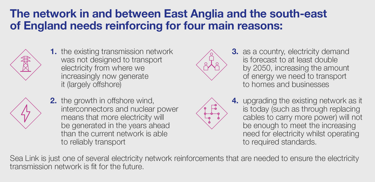
With more of our power coming from renewable energy, including out at sea, and demand rising fast, we need to scale up our network and undertake the largest overhaul of the electricity network in generations.
Suffolk and Kent are both areas where the electricity network needs upgrading, as more power is set to come into the network than it can transport.
Sea Link is part of the solution to add capacity to the network. By using a subsea connection, we are overcoming some of the main pinch points in the network allowing power to flow in either direction to homes and businesses across the country.
Sea Link only works if it is connected in certain locations in Suffolk and Kent.
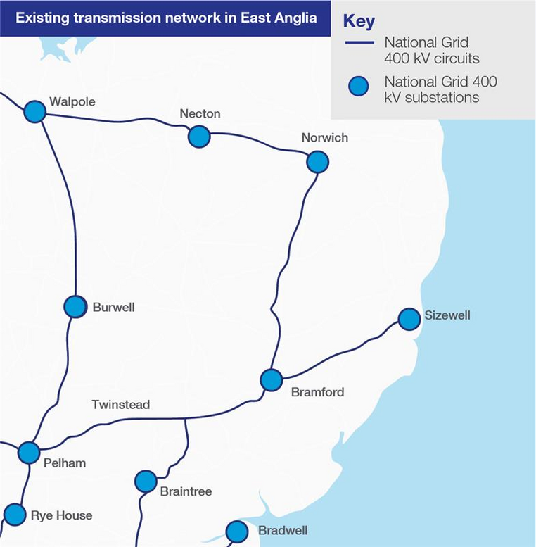
In Suffolk, Sea Link must connect in the Sizewell area to transport power from generators like Sizewell and new offshore wind farms, providing extra capacity in the network for this new generation.
In Kent, the existing network which runs between Kemsley in Sittingbourne (via Canterbury and Richborough) and Lovedean in Hampshire is one area that needs upgrading. This means that Sea Link needs to connect between these two locations
Building Sea Link in a different location would not create more capacity on the network where it is needed.
In Suffolk, our proposals include:
- a connection from the existing transmission network via the proposed Friston Substation, including the substation itself. Friston Substation already has development consent as part of other third-party projects. If Friston Substation has already been constructed under another consent, only a connection into the substation would be constructed by Sea Link
- a high voltage alternating current (HVAC) underground cable of approximately 1.9 kilometres (km) in length between the proposed Friston Substation and a proposed converter station (below)
- a 2 GW high voltage direct current (HVDC) converter station up to 26 metres (including permanent access from the B1121 and a new bridge over the River Fromus) high plus external equipment (such as lightning protection & railings for walkways) near Saxmundham
- a HVDC underground cable connection of approximately 10 km in length between the proposed converter station near Saxmundham, and a transition joint bay (TJB) approximately 900 metres inshore from a landfall point (below) where the cable transitions from onshore to offshore technology
- a landfall on the Suffolk coast (between Aldeburgh and Thorpeness).
You can view the plans for Sea Link on the Our proposals page of this website. Additionally, our application is published in full on the Planning Inspectorate’s website here.
Our marine proposals for Sea Link include:
- Approximately 122 kilometres (km) of subsea high voltage direct current (HVDC) cable between the Suffolk landfall location and the Kent landfall location.
You can view the plans for Sea Link on the Our proposals page of this website. Additionally, our application is published in full on the Planning Inspectorate’s website here.
In Kent, our proposals for Sea Link include:
- a landfall point on the Kent coast at Pegwell Bay
- a TJB approximately 800 m inland to transition from offshore HVDC cable to onshore HVDC cable, before continuing underground for approximately 1.7 km to a new converter station (below)
- a 2 GW HVDC converter station (including a new permanent access off the A256), up to 28 m high plus external equipment (such as lightning protection & railings for walkways), near Minster. A new substation would be located immediately adjacent
- removal of approximately 2.2 km of existing HVAC overhead line, and installation of two sections of new HVAC overhead line (totalling approximately 3.5 km) from the substation near Minster to the existing Richborough to Canterbury overhead line.
You can view the plans for Sea Link on the Our proposals page of this website. Additionally, our application is published in full on the Planning Inspectorate’s website here.
Some major infrastructure projects (such as new overhead power lines, power stations and airports) are classified as nationally significant infrastructure projects. The size and status of these projects means that the decision on whether or not to build them is made by the Government, not your local council.
The Planning Inspectorate has checked the application meets its requirements for Examination. Now the application has been accepted, it has been published in full on the Planning Inspectorate’s website here, where you can also read about the planning process and what happens next.
Click here to watch a short video on the planning process for nationally significant infrastructure projects.
You can view the plans for Sea Link on the Our proposals page of this website. Additionally, our application is published in full on the Planning Inspectorate’s website here.
Yes. Now our application has been accepted, you will have the opportunity to register to participate in the Examination of our plans. As part of the Examination, an independent panel of experts will be appointed to review our application, known as the Examining Authority.
The Examination will include a mix of written questions and in-person hearings, following which the panel will write a report with a recommendation as to whether our application should be approved or refused.
To take part, you will need to register (as an Interested Party) once registration opens.
Since 2022, we have held three rounds of consultation on the proposals: non-statutory consultation in 2022, statutory consultation in 2023, and targeted consultation in 2024. We refined our proposals between each consultation based on feedback received, and the outcome of ongoing survey and technical work across all areas of the project – such as environmental and technical assessments.
In November 2024 we ran a targeted engagement exercise to consult local stakeholders who are in close proximity to a small number of proposed changes to the plans. These changes were the result of further engineering work, environmental assessments and feedback to earlier consultations.
In March 2025 we submitted our application for development consent.
You can read about earlier consultations in detail on the document library of our website and more information on submitting our application is available in the FAQs section. Our application has also been published in full on the Planning Inspectorate’s website here.
In 2023 and 2024, National Grid Electricity Transmission (Sea Link), North Falls (Offshore Wind Farm) and Five Estuaries (Offshore Wind Farm) carried out work to explore the potential for offshore coordination as part of the Offshore Transmission Network Review (OTNR) “Early Opportunities” workstream. The projects, acting together in a consortium led by North Falls, were awarded funding by the Department of Energy Security and Net Zero (DESNZ) through the Offshore Coordination Support Scheme (OCSS) in December 2023.
On 28 March 2024, the consortium submitted a high-level feasibility study that formed the first step of the grant funding agreement. The study assessed the feasibility of a coordinated offshore connection specifically: the capital costs; building blocks; construction and commissioning methodologies and overall programme associated with a coordinated solution.
The Secretary of State for Energy Security and Net Zero subsequently reviewed this study amongst other information and, in September 2024, decided not to grant further funding to the consortium. The feasibility study identified that coordination is technically feasible however, it also identified:
- an increase in capital costs of up to £890m
- constraint costs associated with an outage on Sea Link of over £500m*
- a programme delay for North Falls and Five Estuaries of up to five years
Given the significant extra costs and the negative impact on the delivery timeline of connecting more renewables to the UK energy system, especially considering the government's commitment to quadruple offshore wind and fully decarbonise the UK's electricity system by 2030, the consortium supports the Secretary of State’s decision and will not be further pursuing a coordinated offshore connection. We would like to thank DESNZ for its continued engagement throughout the grant term.
*This figure is attributed to the constraint costs associated with an outage on Sea Link in 2032/33 only.
We are currently in the process of updating stakeholders on the changes we are making to our plans for Sea Link. We intend to make an application for development consent in early 2025, though this date is subject to change.
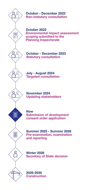
The start of construction depends on our application for development consent being approved. If we receive approval, construction is expected to start in 2026 and completed by 2031, with some reinstatement works continuing into 2032.
Local communities and the environment
In March 2025, the Government published guidance on community benefits for areas that host new transmission infrastructure, such as our proposals for Sea Link.
We welcome the Government’s guidance on community benefits, which supports our view that communities should be rewarded for hosting new transmission infrastructure essential to boosting home grown, cleaner and more affordable power for the country. This guidance offers a clear framework and will enable us to work with communities and deliver meaningful, long-term, social and economic benefits through strategic investment.
In line with this guidance, community benefit funds must respond to community needs and be developed through engagement with communities and stakeholders. As this project develops, we will engage with local residents, community groups, local representatives and range of stakeholders to help shape our proposals for community benefits associated with Sea Link. Please keep an eye out for opportunities to share your feedback with us.
Yes. We have looked at all developments taking place within a 20 km radius of the proposals area.
In Suffolk, this includes projects such as Sizewell C, East Anglia ONE & TWO Offshore Windfarms and LionLink. Across most of the areas studied in the cumulative effects assessment, such as recreation, traffic, noise and vibration, there would be no additional significant impacts arising from cumulative development taking place. Where there is potential for cumulative impacts, such as the impact on landscape and views on the Suffolk Coast and Heaths AONB, these would short-term and temporary impacts which are unlikely to remain once construction has finished, the land restored to its prior condition and planting is more established in the area.
In Kent, this includes projects such as Manston Airport, Stonelees Golf Course extension and Richborough Energy Park. Across most of the areas studied in the cumulative effects assessment, such as recreation, traffic, noise and vibration, there would be no additional significant impacts arising from cumulative development taking place. Where there is potential for cumulative impacts, additional measures are proposed to reduce this to an acceptable level - for example, the landscape and visual impact on Stour Marshes will be mitigated through additional planting, which will separate the site and Richborough Energy Park from the wider marsh landscape.
For more information, see the Environmental statement (part 2, chapter 13 for Suffolk and part 3, chapter 13 for Kent).
There are several key differences between these projects that restrict the ability of the applications to be brought forward as a single DCO.
- Sea Link is part of The Great Grid Upgrade and is an essential network reinforcement and standalone project
- the projects are being promoted by different companies, with different project teams, covering different geographical locations, and are at different stages. This makes coordination into a singular DCO unworkable given the need to deliver Sea Link by 2030
- the businesses are separate legal entities and have different statutory duties.
Sea Link was submitted in March 2025 and LionLink is yet to start its statutory consultation, meaning that submission is currently expected to take place in 2026.
Though Sea Link is not an energy generator, it will allow new, cleaner sources of energy to connect to homes, businesses and public services across the country by increasing capacity on our network. Without increasing capacity, we cannot connect cleaner energy sources. Sea Link alone will connect enough power for two million homes and is one part of our efforts to upgrade and decarbonise the grid.
EMFs are electric and magnetic fields. Electric fields are produced by voltage and magnetic fields by current flowing through a conductor. Overhead lines are a source of two fields: the electric field (produced by the voltage) and the magnetic field (produced by the current). Underground cables eliminate the electric field altogether as it is screened out by the sheath around the cable, but they still produce magnetic fields.
Background EMFs are present in most homes. They come from the house wiring, electrical appliances and the low-voltage distribution cables that carry electricity along streets.
Some people worry that Electromagnetic fields (EMFs) may have negative health effects. We take these concerns seriously and want to keep the public, our contractors and employees safe. We ensure all of our existing and proposed equipment, including those on this project, comply with independent safety guidelines set to protect us all against EMF exposure. After decades of research, the weight of evidence is against there being any health risks of EMFs below the guideline limits.
For further information on EMFs visit our website, www.emfs.info. If you would prefer to talk about your concerns, please do not hesitate to call the EMF helpline on 0845 702 3270 or email [email protected].
Background EMFs are present in most homes. They come from the house wiring, electrical appliances and the low-voltage distribution cables that carry electricity along streets.
Some people worry that Electromagnetic fields (EMFs) may have negative health effects. We take these concerns seriously and want to keep the public, our contractors and employees safe. We ensure all of our existing and proposed equipment, including those on this project, comply with independent safety guidelines set to protect us all against EMF exposure. After decades of research the weight of evidence is against there being any health risks of EMFs below the guideline limits.
For further information on EMFs visit our website, www.emfs.info. If you would prefer to talk about your concerns, please do not hesitate to call the EMF helpline on 0845 702 3270 or email [email protected].
Yes. We have studied the likely significant effects that could occur over the lifetime of the project and identified mitigation measures to avoid, reduce or offset impacts.
Mitigation measures are split into three categories:
- embedded measures: are built into the project design to reduce environmental effects, this means changing the route or layout of infrastructure, works or construction methods to reduce the impact in that area – an example of this is the proposal to install the cable deep below ground at both Pegwell Bay and Aldeburgh Beach to avoid impacting the surface
- control and management measures: are our commitment to good practice when delivering works to minimise impact and disruption, these commitments are set out across documents such as the Code of construction practice and Construction traffic and travel plans – examples include screening the site to reduce noise levels and using haul roads to take construction traffic off the local road network where possible
- additional mitigation measures: are specific measures that would be needed to offset any likely significant effects that cannot be designed or managed out – for example, the loss of acid grassland in Kent will be offset by the enhancement of 6 hectares of acid grassland for at least 10 years.
To view the full list of mitigations proposed for Sea Link, see our Register of environmental actions and commitments here.
Our multi-disciplinary team comprises environmental specialists across the marine and land environments, alongside technical experts (such as engineers, air quality consultants and acoustic specialists) with qualifications in their chosen field. The team’s expertise is set out in the Statement of competence which has been submitted as part of the application.
There are a number of different ways for National Grid to deliver biodiversity net gain for Sea Link. Biodiversity net gain (BNG) means leaving nature in a better state at the end of the project than it was before any works started.
To maximise the environmental benefit, National Grid will provide BNG which can be managed and maintained for at least 30 years and will not be disturbed by future development. On site BNG would include enhancing local habitats and hedgerows, managing invasive (and non-native) species, and planting species that would enhance the biodiversity in the immediate area.
Given the size and scale of the project, some BNG would be delivered off site: 33% of the biodiversity net gain in Suffolk would be delivered on site and 44% of the biodiversity net gain in Kent would be delivered on site. The remainder would be delivered through partnerships, National Grid’s nature and climate framework, and by working with off site providers.
For more information, see our Biodiversity net gain feasibility report which can be found here.
Infrastructure and construction methods
A converter station houses the technology that converts electricity between alternating current (AC) and direct current (DC) and enables it to be transmitted over long distances. AC current is used in each country’s transmission system to power homes and businesses, while DC is used for sending electricity more efficiently over long distances.
Substations house electrical equipment which enables the system operator to control the flow of electricity. These substations come in many sizes and configurations depending on the need. Substations are also key in helping to isolate and fix faults and allow maintenance to be undertaken safely on the electricity network.
Cable joint bays are needed at intervals of approximately 500 metres to 1,000 metres when constructing underground cables, to allow for individual sections of cable to be joined together. In areas where a cable joint bay is needed, a wider cable corridor may be required.
Cable ducts are sections of tubing where electricity cables are placed.
A link box is an above ground kiosk which allows inspection and maintenance of the cables.
Transition joint bays are used to connect an onshore cable to an offshore cable. These are generally around 10 to 15 metres in length, 5 metres in width (dependent on design requirements) and are located near the coast.
Most of the cable route would be installed using open cut installation, there are two types of open cut installation we would use:
- open cut direct buried: typically used in open countryside/agricultural land, it involves excavating a trench for the cables to be laid directly into and backfilling the trench.
- open cut ducted: also used in open countryside/agricultural land, it involves excavating a trench, installing ducts for the cable, and backfilling the trench. Using this method, the excavations are more limited and therefore trenches are open for shorter periods.
Trenchless cable installation will also be used to install the cable where environmental or engineering constraints mean open cut installation is not an option. This approach does not require removing topsoil or subsoil and minimises disturbance at the surface.
We are proposing to install the cable using the open ducted method along most of the route, with some exceptions at the crossing of the A256 in Kent and where the cable comes ashore in both Kent and Suffolk. This means in Suffolk, the cable would also be installed using a trenchless method at the North Warren RSPB Reserve in Suffolk.
You can also read more about our construction methods across Sea Link in our Environmental statement (part 1, chapter 4, section 6) which can be found here.
We have prepared an Outline construction traffic management and travel plan in consultation with local highway authorities - Suffolk County Council and Kent County Council. The purpose of these plans is to set out how we propose to manage construction traffic in a way that limits disruption in the local area.
This includes minimising the volume of traffic, ensuring heavy goods vehicles (HGVs) follow designated routes, limiting the time during which HGVs can arrive or depart from site, promoting car sharing and public transport across the workforce. We are also proposing temporary haul roads so that construction traffic avoids the local road network where possible.
The average number of HGVs per day at the peak of construction would be 68 in Suffolk and 108 in Kent, which means 136 HGV movements in Suffolk and 216 in Kent. As shown in our Environmental Statement, the likely impact of Sea Link on journey times would not be significant.
To read more about this, see our Environmental Statement (part 2, chapter 7, page 94 for Suffolk and part 3, chapter 7, page 85 for Kent) here.
The cables will come ashore deep underground and will be placed there using trenchless construction (directional drilling technology). This means there will be no disturbance to the land surface, and we will not be digging up the beach.
The same is true where the project interacts with the RSPB North Warren, again we will be routing the cable deep below ground.
Draft order limits form the current anticipated boundary of the entire area within which Sea Link could take place.
Limits of Deviation lie within the Draft Order Limits, they give us flexibility when constructing the project in case of unforeseen circumstances (such as unexpected environmental constraints), they allow us to move infrastructure within the Draft Order Limits. We would not need all of the land within the draft order limits, but permanent infrastructure could be installed within the Limits of Deviation.
Yes, potential effects on tourism have been assessed as part of our application. The Environmental Statement looks at footpath or road closures that would impact access, journey times or travel patterns, or where the project interacts with visitor destination sites.
We have minimised impacts through project design, for example, we are proposing to use trenchless construction under the Suffolk Coastal Path where the project interacts with Aldeburgh Beach in Suffolk, and under King Charles III Coastal Path where the project crosses Pegwell Bay in Kent. This means the cable is buried deep below ground and would not impact the surface or those visiting the area for leisure and tourism.
In Suffolk, there are no community or tourism assets within the land being proposed for the project or required as access for the project. While there is potential for noise, visual, traffic and air quality impacts, these can be managed through mitigation measures, such as screening plant and machinery to reduce noise levels in the area.
In Kent, there are no visitor attractions within the land being proposed for the project or for access to the project. While there are a small number of businesses that would be impacted, it would be a short-term and temporary impact that could be managed in agreement with the businesses, ensuring they remain accessible at all times.
Across Kent and Suffolk, there are no roads that would be significantly impacted by construction, nor is there a ‘severance effect’ between residents/visitors and local assets that could potentially cut off access from local amenities and destinations.
To read the assessment and the steps we are taking to reduce impacts, see the socioeconomics, recreation and tourism chapter of our Environmental statement here.
We are proposing temporary haul roads so that construction traffic avoids the local road network where possible. The average number of Heavy Goods Vehicle movements per day at the peak of construction would be 79.
National Grid needs to build a new 400 kV substation in Friston to connect ScottishPower Renewables (SPR)’s East Anglia ONE North and East Anglia TWO offshore windfarms to the existing transmission network. Construction work is yet to begin on the substation.
Cables in these areas would be installed using a trenchless construction method that would not disturb the ground above. We would not be digging up Aldeburgh Beach or the saltmarsh at Pegwell Bay.
The bridge across the River Fromus would provide construction and maintenance access to the proposed converter station near Saxmundham. Using the bridge to access the site would avoid heavy goods vehicles going through the centre of Saxmundham.
At earlier stages in the project, we considered three options for access routes to the proposed converter station. Two of which (a southern access and a northern access which would cover a longer distance and still require a river crossing) were discounted before we submitted our application for development consent.
The western access route we are proposing represents the most suitable, efficient route for construction and permanent access to the converter station.
To view the latest design for the proposed access bridge over the River Fromus, see our Environmental statement (part 1, chapter 4, page 11) here.
The proposed core working hours (unless otherwise approved by the relevant local planning authority) for works in Kent and Suffolk are:
- Monday to Friday: 7am to 7pm
- Saturday, Sundays and Bank Holidays: 7am to 5pm.
Whilst this gives us flexibility to carry out works when and where needed, we do not expect construction activity to take place on every Sunday or bank holiday. There would also be restrictions on the type of activity that can occur on these days such as piling works and HGV deliveries (again, unless otherwise approved by the local planning authority). Our main works contractor would be responsible for the construction programme and deciding if works are required over the weekend.
As the substation near Friston is being delivered under the existing consent secured by ScottishPower Renewables, the construction hours for the substation are different to the main works:
- Monday to Friday: 8am to 6pm
- Saturday: 8am to 1pm.
Offshore, the marine cable installation would be a 24-hour operation where possible.
Where Sea Link would cross the existing Public Rights of Way (PRoW) network, diversions may be required to keep members of the public and our workforce safe. These can be classified into four categories:
- provisions: at these locations, safety measures (such as short-term closures, using stop go boards or similar) would be in place to allow fences, gates, or other safety equipment to be installed
- short-term temporary diversions: at these locations, short-term construction activities would require a diversion on the PRoW while the works take place
- long-term temporary diversions: at these locations, a diversion route would be in place for the duration of the construction programme
- permanent diversions: at these locations, the route of the existing PRoW would be impacted by permanent infrastructure so a permanent diversion route would be required.
In Kent, most of the diversions needed would be short-term (6-months or less) temporary diversions, there are no permanent diversions required for Sea Link. Any affected PRoW would be fully reinstated once the works are complete. A full list of the diversions we expect will be required is set out on page 21 (table 5.1) of the PRoW management plan for Kent.
In Suffolk, two PRoW would require permanent diversions where they cross the proposed substation site near Friston and converter station site near Saxmundham. The majority of the diversions however would be short-term (6-months or less) temporary diversions. Any affected PRoW would be fully reinstated once the works are complete. A full list of the diversions we expect will be required is set out on page 22 (table 5.1) of the PRoW management plan for Suffolk.
There is no such thing as a fully offshore grid. Power will always need to come ashore by cable to reach homes and businesses on land.
Underground and offshore high voltage direct current cables which can carry more power than 2 GW do not yet exist. If they did, it would mean more, not less, onshore infrastructure as more converter stations would be needed to cope with these cables. This is evidenced in the ‘offshore’ solutions being progressed in other countries.
In Belgium, the 3.5 GW from the proposed Princess Elisabeth Island will be connected to the onshore network by up to 10 cables coming ashore. To carry this energy to homes and businesses, over 100 km of new overhead lines and approximately 20 km of new underground cables also need to be built.
The German and Dutch transmission network operator TenneT is building at least 13 individual 2 GW connections from offshore wind farms directly to land. Each connection will use three cables, instead of the two used by Sea Link, and will have a converter station the same size as Sea Link. This approach does not mean that less infrastructure is required.
The evidence shows the offshore grid approach does not mean that less onshore infrastructure is required. An ‘offshore solution’ would not be faster or cheaper. It would involve a significant redesign of our project, delay the delivery of Sea Link and prevent new renewable energy connecting when it is ready. This will be costly to the economy, the environment and electricity bill payers.
Whilst we always look to new technologies and different ways to future-proof the network, it is vital that Sea Link is in place by 2030.
The Great Grid Upgrade
What's energy resilience got to do with movie marathons? Find out how – and why – we’re connecting more clean energy to power the things you love.